
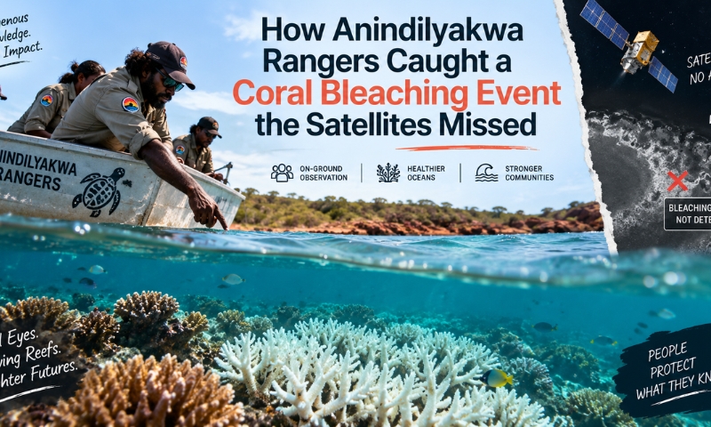
But long before any scientist did show up with a boat loaded with equipment, the Anindilyakwa people who know the reefs around Groote Eylandt best, noticed something was amiss. Coral bleaching was first noticed on Anindilyakwa Island in early 2024, the color of coral reefs was changing. It was before the International Monitoring and Assessment of Stressed Reefs reported any alarm to the world about coral bleaching.That gap between what the technology predicted and what was actually happening on the reef has become the starting point for one of the most detailed scientific surveys ever conducted in these waters.
A Reef Almost Nobody Had Studied
Groote Eylandt is located in the remote corner of the Northern Territory in the Gulf of Carpentaria, where even living coral reefs on the wider northern coast of Australia have only been documented in 2004. There have since been only a few studies of reefs in the area, and a none of these had been specifically on the coral around Groote Eylandt. But all that has changed, thanks to the work of the rangers and researchers from the University of Technology Sydney who have published their first extensive baseline study in the archipelago journal.
Lead author and UTS PhD researcher Dane Wattle surveyed five reef sites across four days in mid-2024, using a remotely operated underwater vehicle rigged with a camera. The results varied dramatically from site to site, with hard coral cover ranging from as little as five per cent at one location to almost half the seafloor at the richest. Rather than the branching corals often seen further east, the team found the reefs dominated by hardier, more solid structures.
When the Models Got It Wrong
UTS researcher Emma Camp said satellite data had shown sea temperatures were elevated in the lead-up to the fieldwork, but not at levels typically linked to coral bleaching. Global predictive models, in other words, saw nothing worth flagging The coral bleaching event was detected and confirmed only due to the existing monitoring of the reef by the Anindilyakwa rangers, who observed the reef directly on the water. Ground level connections made the difference between not knowing if we were going to have bleaching in Groote Eylandt, or understanding why it happened, she said, explaining that we have global models that help us predict when reef will bleach, but none predicted that we were going to have bleaching in Groote Eylandt at that time.
The timing made things harder still. Fieldwork took place only months after Tropical Cyclone Megan tore through Groote Eylandt at category three intensity, damaging vegetation and infrastructure on the island and leaving the reef itself bruised from the storm. Camp said cyclones can physically break apart a reef’s structure even as the reef absorbs wave energy that would otherwise erode the coastline, meaning the survey captured a system dealing with two kinds of stress at once rather than a single clean bleaching signal.
Crocodiles, Stingers and a Job That Demands Focus
Fieldwork of this kind isn’t straightforward in the crocodile-inhabited waters of the Northern Territory. Anindilyakwa Land Council’s Kirsten Eden said the presence of saltwater crocodiles, box jellyfish and other marine stingers, combined with unpredictable weather, had kept researchers away from these reefs for years, long before the coral bleaching event even became a concern. The eventual survey became a genuinely coordinated operation, with drones scanning from above, spotters stationed on boat roofs, and a remotely piloted underwater vehicle doing the close-up work human divers couldn’t safely attempt.
Rangers were trained to pilot both the drones and the underwater vehicle themselves, meaning the monitoring program can continue without university researchers needing to return each time. Eden said the five survey sites were chosen by rangers based on traditional knowledge of which reefs held the greatest cultural and ecological significance, rather than being picked at random from a map.
A Baseline, Not the Full Picture
Researchers are careful to note the survey is a single snapshot rather than an ongoing study, captured four months after the coral bleaching event and three months after the cyclone, meaning it likely doesn’t reflect the reef at full health. Sea Country makes up around 70 per cent of the Anindilyakwa Indigenous Protected Area, yet legal protections for marine environments in the Northern Territory remain far weaker than those covering land under the Aboriginal Land Rights Act.
With a nearby manganese mine on Groote Eylandt facing eventual closure and a proposed ocean outfall raising fresh questions, the rangers and researchers involved say the real value of this work lies in what comes next: a continuing, locally led monitoring program that no longer has to rely on distant satellites to know when something is wrong beneath the water.